Posts

Showing posts from May, 2021

Copper Clad Aluminum Wire

Image
  Aluminum wire is 61% as conductive a copper and only 30% of the weight .   So for the same amount of conductance it is half the weight.   Since weight is an important thing on a solar airplane, this is interesting.  The first problem is that the layer of oxide on aluminum makes it very hard to solder to.   We need to connect wires together, so this is a problem. There are copper clad aluminum wires .   The core is aluminum but the outside is copper.   This way you get most of the light weight of aluminum but you can still solder to it like copper.   Below is a picture: A bundle of thin strands seem to have a bad reputation for corroding if outdoors.  I am hopeful that a single solid core, about 1.5 mm diameter, would last well enough for me.  However, I am can't find this on Amazon so far. There is a place in China that might work .   There is a useful website for calculating power loss in a wire depending on type, thickness, length, and load on wire.  And another similar online

SN1 - First custom plane

Image
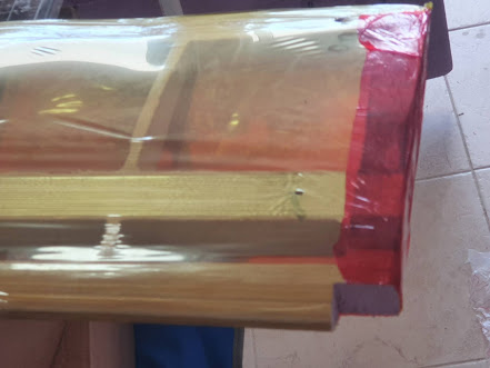
We are working on a clean sheet wing design that has perfect places for 8 solar panels, Jetson nano, DJI Air Unit, supercapacitor, motors, servos, wires, etc.  But the CAD software for this is at the office and in our current Covid situation working on solar airplanes is "non essential", so not a good enough reason to leave the house.   Also leaving your house to fly RC airplanes has been against the law for the last 3 weeks, as I understand it.   We have planned to eventually make a VTOL plane.  Since such a plane could fry from our house, even during lockdowns, this seems like a higher priority now. Also, we have the "test wing" that we made just to see if the idea of CNC cutting a frame out of foam and covering it was reasonable.  We can probably make get this to fly and learn something, since it is at home and we can play with it.   This can be a step toward our VTOL plane. The first step was to use a hacksaw to cut out a bit from each leading corner so we could

Cloud Dodging in the Caribbean

Image
  Caribbean clouds are often only covering part of the sky.   If there was 30% cover and we flew our plane around randomly we would have much reduced solar 30% of the time.   But if we planned our route to optimize solar power, we could do much better than that.   At first we could do this manually but eventually we would like AI to deal with this automatically.        With a Jetson Nano we have plenty of power to work on this problem. If we had it tracking clouds objects (number for each cloud) as we moved to the side we could see how much the angle changed for each of the clouds and figure out how far away they are.   This type of depth perception is called depth from motion .   I think this won't be too hard really.   Some papers related to this topic 1)  Cloud Detection System for UAV Sense and Avoid: Cloud Distance Estimation using Triangulation     $33 US for non-members   Abstract: Sense and Avoid is gaining importance in the integration of unmanned aerial vehicles (UAVs)

Motor Mount in Foamular 250

Image
 The Foamular 250 we are using is rated for compression of up to 25 psi (lbs/sq-inch).   It is more stiff than other foam I have seen in model airplanes and a bit heavier.   We cut out the foam where we don't need the strength, so we are not hurt by the weight.   For motor mounts it seems like this extra strength could let us just gorilla glue some screws into the foam.   We tried this and it seems to work fine.  For this experiment we used M2x20 screws.  So 2 mm diameter and 20 mm long.  The motor mount uses 4 screws but for this test we only used 2.   We drilled two holes in the foam and filled them with water (poking small nail in to get all the air out).   Then we covered the screws with gorilla glue and put them in.  First we tried just putting a weight on to hold them in: But it was hard to get it to hold both screws down well.   So we put a piece of plastic over and a clamp and let it cure overnight. So for the test this is what it looked like: And here is the video of the t

Stabilized Camera / Pan-Tilt

Image
  With a "two servo micro gimbal" you can tell iNav to stabilize your camera.  The flight controller already has tilt sensors and a computer, so with the iNav software setup right it can control the servos and stabilize a camera.  You do need to have 2 extra servo outputs on the flight controller.     There are a number of these on Amazon.   If we just search Amazon for "servo gimbal Mini Pan-Tilt mount FPV" there are several for under $25 but you may have to put in your own servos.        You can also 3D print the plastic parts and add your own servos.   This is for a Raspberry Pi or Jetson Nano type camera but should not be hard to get it to hold a DJI Camera. There are also head trackers so that the airplane can point the camera where you turn your head.  This increases the feeling of being on the airplane, so can increase the fun.

Mr Watt Solar Plane

Image
  We bought a solar plane from Mr Watt more than a years ago but with Covid and other things we did not unbox it till today.   Below Teryn and Amoni are opening the box:   And out of the box but not ready to fly it looks like this.   It is really big. When they did a test flight in Italy it looked like this: Along with Covid part of the delay was we did not know of a place to fly it.  Anguilla's two large grass fields both have problems.  One is in town near the airport.  The other is under the approach path to the airport.     We had hoped to work out landing in a net and did fly a plane into a net on a couple occasions but were not happy with this idea.   Since then we have found a remote beach that seems a good place to fly from .    Another problem was how to do the camera, energy storage, computer, and radio control in the rated 500 grams.  We did not know how to do this when we ordered the plane but expected we would at some point.   We have recently  figured out how to hav

Jetson Nano and AI / Vision

Image
  It would be nice if a solar drone could detect ships for boarder patrol, people in the water for rescue, and clouds for maximizing solar collected by the plane.  It could then plan a route to get closer pictures of ships or people and avoid clouds.  This paper on ship detection also compares Jetson Nano to Raspberry Pi and shows that Jetson gets more processing per watt.   We have thought this too and have been playing some with Jetson Nano.   In ArduPilot a Jetson Nano can be the companion computer for both 4G cell data and for image processing/AI stuff.  It can run at 5 watts and is about 135 grams.    The Jetson Nano is about $100. It has a big brother the Jetson Xavier NX that is about the same but with a fan and 15 watt top instead of 10 watt.  The NX costs about $400 and has about 10 times the AI performance of the Nano.  Though with the NX you probably also want a fast SSD, which could add another $100 or so.  After we get good enough that don't lose airplanes too often,

S800 Group Build, Project Rosetta Stone

    This seems a great source for learning iNav:   S800 Group Build, Project Rosetta Stone    

Cellular Data Connection

Image
 If we can use cellular data to connect to the airplane then it could go really far and we could stay connected. 4gUAV Peter J Burke connected 4G to an airplane and wrote about it .  He also wrote some later papers with projects using 4G .  So far we are just looking at how to do it but will probably do this at some point.   The first thing is a USB to 4G adapter like:     Next a very tiny Raspberry Pi Zero W : Then it seems ArduPilot is needed.  It runs on the flight controller but talks with the Raspberry Pi as a companion computer .   The 4G modem plugs into the Raspberry Pi.   Peter has setup a 4gUAV gitlab repository that is really the place to go.  Here is a video where Peter flies a plane just from over cellular. UAVPAL Disco4G   Also interesting is  UAVPAL Disco4G .  This uses a drone that can operate over wifi and puts a cell hotspot/wifi on it.  This has latency issues for control.   Over a cell network it is probably more reasonable to be sending GPS waypoints and not tryi